As an Amazon Associate, I earn from qualifying purchases with no additional costs for you.


This guide pulls together everything worth knowing about rockhounding in California — the best public and pay-to-dig sites, the rocks and minerals you can realistically find, and where the state’s famous geode beds are.
The key legal fact: collecting is banned outright in national parks, but generally allowed on BLM and national forest land. State parks set their own rules, usually capping you at 15 lbs per day with no tools.
Start with Wiley’s Well for geodes and fire agate, the Kramer Hills for agate and jasper, and the Trinity River for jade and gold. Quick tip: California has far more private land than most western states — check ownership before you dig.
Rockhounding Regulations & Laws in California
California’s rules vary more by land manager than almost any other state, and the penalties for getting it wrong in a national park are real. Work out who owns the ground before you plan the trip.
- National parks — prohibited. No collecting of any kind. Do not confuse these with BLM land or national forests.
- BLM land — generally allowed. Casual collecting for personal use, using hand tools. The BLM’s “Can I Keep This?” guide sets out what you may and may not take.
- State parks — limited. Each park sets its own rules, but the usual cap is 15 lbs per day, tools are generally not permitted, and everything must be for a personal collection.
- National forests — generally allowed, though individual forests add their own conditions. Modoc National Forest, for example, issues its own obsidian collecting permits.
- Never commercial. Selling what you collect is not permitted on public land under any of these regimes.
Vertebrate fossils and archaeological artifacts are off-limits everywhere on public land. California also has a great deal of private land in its mineral-rich areas, so an unmarked site is not automatically open.
Use this guide as a starting point, not a final authority. Follow posted signage, and always get the landowner’s permission before collecting on private property.
Access rules and land ownership change over time, so confirming that collecting is currently allowed — and whether a permit is required — is your responsibility. Where coordinates are listed, treat them as a general reference only. How to Find Rocks is not responsible for the accuracy of the information here or for any outcome resulting from its use.


Best Rockhounding Sites in California
California’s sheer size gives it more variety than almost anywhere else — desert geode beds in the south, jade and gold in the northern rivers, and obsidian in the volcanic northeast. The map below plots the main sites in this guide.
The table below breaks down each site — what you can expect to find, whether it is public or pay-to-dig, and roughly how to get there.
| Site | Region | Access | GPS Coordinates | What You Can Find | How to Get There |
|---|---|---|---|---|---|
| Wiley’s Well | Southern CA (Riverside County) | Public | 33.4939 N, 114.8897 W | Fire agate, geodes, citrine, chalcedony, jasper, quartz | BLM geode beds district in the Colorado Desert, south of I-10 near Blythe |
| Hauser Geode Beds | Southern CA (near Blythe) | Public | 33.7642 N, 115.4236 W | Geodes, agate | About an hour southwest of Blythe off I-10; high-clearance vehicle advised |
| Kramer Hills | Southern CA (near Boron) | Public | 34.9208 N, 117.4686 W | Agate, jasper, peridot, petrified wood, opalite | East of Boron; from Kramer Junction where Hwy 58 meets US 395 |
| Crystal Peak Mine | Northeastern CA (Humboldt-Toiyabe NF) | Public | 39.5958 N, 120.0766 W | Quartz crystals, geodes | Crystal Peak in the Humboldt-Toiyabe National Forest |
| Alvord Mountains | Southern CA (Mojave) | Public | 35.0688 N, 116.6263 W | Agate, chalcedony, petrified wood, malachite, chrysocolla | Alvord Mine area northeast of Barstow |
| Chambless Trilobite Quarry | Southern CA (Mojave) | Public | 34.5625 N, 115.5225 W | Trilobite fossils, garnet, magnetite, epidote | Within the BLM Chambless Rock Collecting Area, reached from Needles |
| Pebble Beach (Crescent City) | Northern CA (Del Norte County) | Public | 41.7650 N, 124.2309 W | Agate, jasper, jade | Beaches around Crescent City — best after winter storms |
| Diamond Creek | Northern CA | Public | 41.9558 N, 123.9352 W | Quartz, agate | Creek gravels in the northern mountains |
| Trinity River | Northern CA (Trinity County) | Public | 40.8791 N, 123.5270 W | Jade, serpentine, gold | The Trinity runs 165 miles through the Klamath Mountains |
| Modoc National Forest | Northeastern CA | Public (permit) | 41.6015 N, 121.5044 W | Obsidian, rainbow obsidian | Permit required — obtain it from the forest office before collecting |
| Benitoite Mining Company | Central CA (San Benito County) | Pay-to-dig | 36.2426 N, 120.5972 W | Benitoite, neptunite | The only commercial source of gem benitoite in the world |
| Himalaya Tourmaline Mine | Southern CA (Santa Ysabel) | Pay-to-dig | 33.2340 N, 116.7625 W | Tourmaline, quartz, lepidolite | Check current status before travelling — on-site digs have been suspended at times, though ore buckets ship by mail |
Other Notable Rockhounding Spots in California
Beyond the headline sites, California has dozens of smaller spots worth a detour. These split fairly cleanly between the desert south and the river country of the north.
Southern California
The southern sites are desert country — geode beds, agate and old mine dumps, all best worked outside the summer heat.
| Site | GPS Coordinates | Common Rocks / Minerals |
|---|---|---|
| Afton Canyon | 35.029136, -116.363102 | Geodes, quartz, fluorite |
| Victor Mine | 33.264189, -116.939199 | Cookeite, bismuth |
| Rouse Hill Pegmatite Outcrops | 33.672586, -116.772378 | Amazonite, rose quartz, tourmaline |
| Little Acorn Mine | 35.716667, -118.500000 | Epidote, quartz, smoky quartz |
Northern California
The north is river and mountain country, where jade, gold and serpentine dominate the finds.
| Site | GPS Coordinates | Common Rocks / Minerals |
|---|---|---|
| North Fork Eel River | 39.935460, -123.358892 | Nephrite, jadeite |
| Jade Mines Area | 41.876563, -123.460240 | Jade, gold, serpentine |
| Jenny Creek | 41.976920, -122.397776 | Agate, fossils, petrified wood |
| Leech Lake | 39.917706, -123.086825 | Nephrite, jadeite |
| Shady Run Gravels | 39.206918, -120.742549 | Garnet, serpentine |
Common Rocks & Minerals You Can Find in California
GPS coordinates are a general reference only — always confirm access rules and land status before you go.
California’s geology is the product of a long-lived plate boundary — subduction built the Franciscan rocks of the coast, volcanism built the northeast, and hydrothermal systems seeded the gold that started the Gold Rush.


If you would rather work from a proper field guide while you are out there, these are worth keeping in the truck.
BTW: Do you want to know more about rock and mineral identification? The books listed below are the best ones you can find on the internet (Amazon links):
- Smithsonian Handbooks: Rocks & Minerals
- Gemstone & Crystal Properties (Quick Study Home)
- Ultimate Explorer Field Guide: Rocks and Minerals (National Geographic Kids)
Here is a quick overview of the 17 rocks and minerals California rockhounds look for most. Photos, identification tips and GPS coordinates for each one follow below. Click any name in the table to jump straight to its photo, identification tips and GPS coordinates.
| Rock / Mineral | Type | Best Places to Look |
|---|---|---|
| Serpentine | Rock | Trinity River, Trinity County |
| Agate | Rock | Jalama Beach, Crescent City beaches |
| Geodes | Rock | Crystal Mountain, Traverse Creek |
| Obsidian | Rock | Glass Mountain, Davis Creek |
| Blueschist | Rock | Two Harbors (Catalina), Franciscan belt |
| Anorthosite | Rock | San Gabriel Mountains |
| Chinese Writing Rock | Rock | Auburn, American River |
| Gold | Mineral | South Yuba River, Downieville |
| Benitoite | Mineral (state gem) | San Benito County |
| Jade | Mineral | Jade Cove (Big Sur) |
| Tourmaline | Mineral | Pala, Himalaya Mine |
| Rhodonite | Mineral | San Gabriel Mountains, Trinity County |
| Chrysocolla | Mineral | Twentynine Palms, Cerro Gordo |
| Malachite | Mineral | Blue Bell Mine, Copper Prince Mine |
| Aquamarine | Mineral | San Diego and Riverside counties |
| Colemanite | Mineral | Death Valley and Mojave borate districts |
| Garnet | Mineral | Ramona, Pala (San Diego County) |
Rocks
California’s rock list is unusually long, the result of a plate boundary that has stayed active for millions of years.


Serpentine
How to recognize it: Green to black, often mottled like snakeskin, with a waxy or greasy shine and a smooth, almost soapy feel.
California’s state rock. Some varieties carry asbestos, so avoid cutting or sanding it without proper protection.
| Location | GPS Coordinates |
|---|---|
| Trinity County (general area) | 40.89, -122.71 |
| Trinity River | 40.768530, -123.126335 |
| Watts Valley | 36.933906, -119.359318 |
| Jade Mines | 41.876563, -123.460240 |
| Shady Run Gravels | 39.206411, -120.742092 |


Agate
How to recognize it: Translucent when held up to light, with a waxy shine and banded, lace or moss-like patterns inside.
Lace, banded and moss agate all occur here. The beaches are best worked after winter storms, when fresh gravel is exposed.
| Location | GPS Coordinates |
|---|---|
| Jalama Beach | 34.510485, -120.502106 |
| Crescent City Beaches (Pebble Beach) | 41.765000, -124.230900 |
| Bullion Mountains | 34.379015, -115.941243 |
| Agate Beach | 41.143737, -124.144279 |
| Turtle Mountain | 34.285731, -114.851190 |
| Jenny Creek (Siskiyou County) | 41.976920, -122.397776 |
| Kramer Hills | 34.922445, -117.465284 |
| Goose Lake | 41.917611, -120.362579 |


Geodes
How to recognize it: Round, lumpy rocks with a plain, rough outside that often feel lighter than they look when hollow.
Agate, quartz, opal, amethyst, chalcedony and colemanite geodes all turn up in California.
| Location | GPS Coordinates |
|---|---|
| Crystal Mountain | 39.557253, -120.088858 |
| Black Mountain | 33.159609, -116.807438 |
| Traverse Creek | 38.858273, -120.813731 |
| Slate Mountains | 38.823178, -120.685422 |
| Hauser Geode Beds | 33.764178, -115.423562 |
| Pino Grande | 38.869911, -120.625215 |
| Riverside County (general area) | 33.51, -115.87 |


Obsidian
How to recognize it: Natural volcanic glass: glossy, usually black, and it breaks with smooth, curved, razor-sharp edges.
Rainbow obsidian, the rarest type, is found here. Modoc National Forest requires a permit.
| Location | GPS Coordinates |
|---|---|
| Warner Mountains | 41.449700, -120.251401 |
| Middle Fork Davis Creek | 41.725416, -120.314262 |
| Glass Mountain | 41.601001, -121.504565 |
| Gem Hill | 34.924032, -118.221488 |
| Modoc National Forest | 41.499778, -121.001532 |
| Pisgah Crater (private property — permission required) | 34.744959, -116.375535 |
| Obsidian Dome | 37.758690, -119.021066 |
| Obsidian Butte | 33.170683, -115.637406 |


Blueschist
How to recognize it: Blue-gray to lavender rock with thin, flaky layers, colored by the blue mineral glaucophane.
A high-pressure, low-temperature metamorphic rock formed in the old subduction zone.
| Location | GPS Coordinates |
|---|---|
| Two Harbors Beach | 33.441395, -118.498073 |
| Klamath Mountains | 41.319579, -122.480387 |
| Oakland | 37.872516, -122.231201 |
| Cazadero | 38.537123, -123.085046 |
| Condrey Mountain | 41.937437, -122.979464 |

Anorthosite
How to recognize it: Light gray to white, coarse-grained, made almost entirely of large plagioclase feldspar crystals.
A coarse, plagioclase-rich igneous rock; the San Gabriel body is one of the best-known in the US.
Photo: Kevin M. Gill / Wikimedia Commons, CC BY 4.0
| Location | GPS Coordinates |
|---|---|
| San Gabriel Mountains | 34.288145, -117.652508 |
| Santa Clarita (general area) | 34.45, -118.45 |
| Fish Fork | 34.302681, -117.665125 |
| Big Butch Wash | 34.262080, -117.637487 |
Chinese Writing Rock
How to recognize it: Dark rock scattered with white, needle-like feldspar crystals that look like brushstroke characters.
Popular with cutters for cabochons and slabs because the pattern shows best when polished.
| Location | GPS Coordinates |
|---|---|
| Auburn | 38.899187, -121.057960 |
| North Fork American River | 38.884089, -121.059505 |
| Yuba River | 39.298045, -121.211597 |
| Lake Clementine | 38.944228, -121.007062 |
| Foresthill | 38.995502, -120.816647 |
| Middle Fork American River | 38.955599, -120.939728 |
Minerals
The mineral list runs from the internationally famous to the genuinely unique.


Gold
How to recognize it: Heavy, soft and bendable, and it stays bright yellow even in shade, unlike glittering pyrite.
California’s state mineral and the mineral behind the 1848 Gold Rush; many state parks preserve the old mining sites.
| Location | GPS Coordinates |
|---|---|
| South Yuba River | 39.292951, -121.191442 |
| Downieville | 39.563273, -120.825906 |
| Trinity River | 40.768903, -123.126577 |
| Merced River | 37.602962, -120.104713 |
| Santa Clarita (general area) | 34.42, -118.51 |
| Butte Creeks Fork Recreation Area | 39.908930, -121.617997 |
| Kern River | 35.923088, -118.499963 |


Benitoite
How to recognize it: Sapphire-blue crystals with a triangular outline that glow bright blue under shortwave UV light.
California’s state gem, found in gem quality essentially nowhere else on Earth.
| Location | GPS Coordinates |
|---|---|
| Benitoite Mining Company (San Benito County) (approximate) | 36.2426 N, 120.5972 W |


Jade
How to recognize it: Dense, very tough green stone with a waxy shine, usually found as smooth, heavy beach cobbles.
Nephrite jade washes up along the Big Sur coast, and Jade Cove is the classic locality.
| Location | GPS Coordinates |
|---|---|
| Jade Cove | 35.913048, -121.470218 |
| Big Sur | 36.361913, -121.897156 |
| Butte County (general area) | 39.64, -121.55 |
| Feather River | 39.169625, -121.614687 |
| Happy Camp | 41.793526, -123.371168 |
| Eel River | 40.604914, -124.195250 |
| Lake Mendocino | 39.212251, -123.164945 |


Tourmaline
How to recognize it: Long crystals with lengthwise grooves and a rounded triangular cross-section; black is most common, pink and green are the prized colors.
San Diego County pegmatites produce colors said to rival ruby and emerald.
| Location | GPS Coordinates |
|---|---|
| Himalaya Mine | 33.213604, -116.800044 |
| Oceanview Mine | 33.389879, -117.049723 |
| Pala | 33.362594, -117.075998 |
| Queen Mountain (Pala district) | 33.389422, -117.070120 |
| Lake Henshaw | 33.232571, -116.754866 |
| Alpine (general area) | 32.86, -116.78 |
| Fresno (general area) | 36.88, -119.75 |


Rhodonite
How to recognize it: Rose-pink stone crossed by black veins of manganese oxide.
California material is usually pink with distinctive black veining, prized for cabochons.
| Location | GPS Coordinates |
|---|---|
| San Gabriel Mountains | 34.287648, -117.651950 |
| Trinity County (general area) | 41.03, -122.74 |
| Eureka (general area) | 40.80, -124.17 |
| Portal Ridge | 34.706070, -118.520174 |
| Lancaster (general area) | 34.73, -118.16 |
| Wrightwood | 34.364168, -117.628447 |


Chrysocolla
How to recognize it: Bright blue to blue-green, soft and often chalky, frequently mixed with green malachite.
A copper mineral, often intergrown with malachite in the old desert mine dumps.
| Location | GPS Coordinates |
|---|---|
| Blue Bell Mine | 35.245270, -116.205760 |
| Reward Mine | 36.751288, -118.050905 |
| Cerro Gordo Mine | 36.538827, -117.791057 |
| Twentynine Palms (general area) | 34.16, -116.14 |
| Trona (general area) | 35.76, -117.39 |
| Joshua Tree (town, outside the national park) | 34.145867, -116.323943 |
| Milpitas (general area) | 37.46, -121.88 |


Malachite
How to recognize it: Light to dark green with swirling bands, soft, and usually found with calcite and blue azurite.
There is plenty of copper in California, so malachite turns up in and around the old copper mines scattered across the state.
| Location | GPS Coordinates |
|---|---|
| Blue Bell Mine | 35.243693, -116.207649 |
| The Malachite | 34.797800, -120.034200 |
| Copper Prince Mine | 38.792500, -122.674700 |
| Blue Star Mine | 37.122051, -118.411026 |
| Santa Barbara (general area) | 34.45, -119.70 |
| Pocahontas Mine | 37.343630, -120.064107 |


Aquamarine
How to recognize it: Pale blue to blue-green, glassy crystals, often six-sided and long, and hard enough to scratch glass.
California aquamarine is prized for its clarity and ocean-blue color. Some rockhounds find emerald alongside it, though that is a much rarer find.
| Location | GPS Coordinates |
|---|---|
| San Diego (general area) | 32.92, -117.02 |
| Riverside County (general area) | 33.86, -117.30 |
| Lake Henshaw | 33.230992, -116.755295 |
| Tourmaline Queen Mountain | 33.389422, -117.070120 |
| Williamson Mine | 33.557546, -116.791862 |
| Cahuilla Mountain | 33.576514, -116.783763 |
| Pala | 33.374156, -117.076943 |

Colemanite
Where to find: Death Valley and Mojave borate districts
How to recognize it: Colorless to white glassy crystals, short and blocky, found in desert borate deposits.
A borate mineral that also forms geodes in parts of the desert. Collecting inside Death Valley National Park is not allowed.
Photo: U.S. Bureau of Mines / Wikimedia Commons, public domain

Garnet
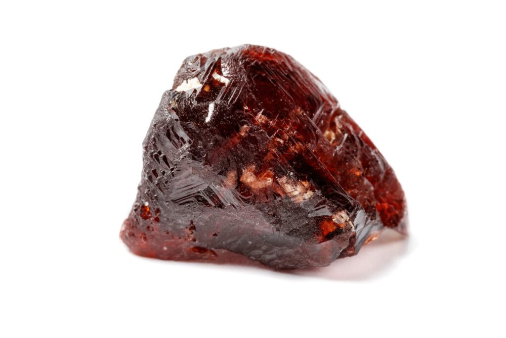
How to recognize it: Glassy, rounded crystals with many flat faces; the prized local spessartine is a deep, rich orange.
Southern California is known for gem-grade spessartine garnet, popular as a gemstone. Grossular garnet also occurs, but spessartine is far more sought after.
| Location | GPS Coordinates |
|---|---|
| Ramona (general area) | 33.01, -116.86 |
| San Diego (general area) | 32.76, -117.06 |
| San Bernardino (general area) | 34.09, -117.26 |
| Pala | 33.373260, -117.079389 |
| Hatfield Creek | 33.057830, -116.852396 |
| Rincon | 33.289279, -116.961266 |
| Gem Hill | 34.924032, -118.221144 |
Where to Find Geodes in California
California is one of only two states on this site with a dedicated geode guide — the desert beds in the south are among the best-known in the country, and the northern mountains hold quieter alternatives.


Chalcedony, amethyst, agate, opal, quartz and colemanite geodes all occur here. The southern desert beds are the productive ones; the north takes more searching but sees far less traffic.
Northern California
- Crystal Mountain — quartz and agate geodes in the surrounding slopes.
- Pino Grande — a long-worked area in the El Dorado country.
- Slate Mountain — agate and chalcedony geodes.
- Peterson Mountain — better known for quartz crystals, but geodes occur alongside.
Central California
Central California holds good material but far more private land, so research ownership carefully before setting out. Creek gravels and canyon exposures are the usual targets.
Southern California
- Wiley’s Well district — the classic BLM geode area, with several distinct beds.
- Hauser Geode Beds — southwest of Blythe, about an hour in on rough road.
- Afton Canyon — geodes alongside quartz and fluorite.
- Black Mountain — chalcedony and agate geodes in the desert washes.
State Rock, Mineral, Gem & Fossil of California
California was the first state to name an official state rock, back in 1965. Its four geological symbols are worth knowing before you head out.
| Symbol | Name | Year | Notes |
|---|---|---|---|
| State rock | Serpentine | 1965 | Chosen for its economic value; some varieties contain asbestos, so handle it with care. |
| State mineral | Native gold | 1965 | Naturally occurring gold, the mineral behind the 1848 Gold Rush. |
| State gem | Benitoite | 1985 | First identified in 1907; gem-quality crystals come only from San Benito County. |
| State fossil | Saber-toothed cat (Smilodon californicus) | 1973 | Famous for its long upper canines; designated by Assembly Bill 940 in 1973. |
Rockhounding Clubs in California
A local club is the fastest way to learn which sites are currently productive and which have been closed or claimed. Most run regular field trips.
- Mineralogical Society of Southern California — a long-running scientific non-profit with regular meetings, field trips and educational programmes.
- Fallbrook Gem and Mineral Society — based in Fallbrook in northern San Diego County, close to some of the best gem mining sites in the country, with field trips, classes, meetings, its own free museum and a gift shop.
- Santa Rosa Mineral and Gem Society — a Sonoma County non-profit focused on mineralogy and geology education.
- Roaring Camp Gold — a working gold mine open May to September for panning, sluicing and metal detecting.
- Gold Panning California — a family-run operation near Jamestown running year-round tours.
Recommended Rockhounding Gear
While special gear is not required to find nice rocks and fossils, having the right tools will help you find more than what’s simply laying around on the open ground. Here are some of the more basic tools and safety gear for interested rockhounds.
Geological Hammer
This 22oz Pointed-Tip Rock Pick by Estwing (Amazon link) is recommended for its durability and shock-reducing grip.
A rock pick is essential when collecting mineral specimens from a hard substrate such as stone. The pick’s handle is shock-resistant, making it more comfortable for use for longer times in the field.
Geology Pick
The Geology pick by Estwing (Amazon link) is a good choice for those starting out in the hobby as well as seasoned professionals.
The hammer comes with a pointed tip on one side of the head and a chiseled end on the other. This pick is good for excavating interesting mineral and fossil specimens.
Mini Shovel
The Mini D-Handle Round Point Shovel by Stanley (Amazon link) pairs convenience with durability. Especially in areas of soft material such as sand or clay, it is nice to have a sturdy shovel that is easy to carry.
The D-shaped handle gives you more leverage when digging on your knees, which is something that similarly sized standard-handled shovels wouldn’t provide.
Heavy Duty Work Gloves by Ironclad
Working with your hands in rockhounding environments can be rough; it is easy to get cuts or abrasions when in the field. Protecting your hands is important, especially while working with sharp or abrasive rocks.
The Heavy Duty Work Gloves by Ironclad (Amazon link) protect your hands from sharp rocks and tools. They are machine washable, highly abrasion resistant, and durable.
Safety Glasses
Eye protection is a must when breaking up a rock or any sort of work where debris could cause injury to your eyes.
The 3M Safety Glasses (Amazon link) are anti-fog and have a corded earplug system, as well as a removable foam gasket. The clear, scratch-resistant lenses shield the eyes against harmful ultraviolet light as well as prevent eye injury from flying rock chips.
First Aid Kit
With its 299 pieces, the Only Emergency First Aid Kit (Amazon link) is a good one for rockhounds. Of course, it’s best to avoid injuring yourself but if things go wrong it’s good to be prepared.
Some of the items found in the kit include fabric and plastic bandages, painkillers, gauze and pads, cold packs, wound closers, and many more.
FAQ About Rockhounding in California
These are the questions that come up most often when people plan a California trip.
What rare rocks can you find in California?
Rainbow obsidian is the standout — the rarest form of obsidian, and California is one of the few places it occurs. Blueschist and Chinese writing rock are also unusual finds.
What rare minerals can you find in California?
Benitoite, the state gem, is found in gem quality in essentially one place on Earth: San Benito County. Neptunite occurs alongside it, and San Diego County tourmaline is world-class.
What is the most famous rock or mineral found in California?
Gold, without question — it triggered the 1848 Gold Rush and shaped the state. Benitoite is the more distinctive find, but gold is the one California is known for.
Do I need a permit to collect rocks in California?
Not on most BLM land for personal-use collecting. Some national forests require one — Modoc issues obsidian permits. State parks have their own limits, and national parks prohibit collecting entirely.
Conclusion
California packs more rockhounding variety into one state than almost anywhere else — desert geode beds, coastal jade, volcanic obsidian and Gold Rush country are all here.
The one thing that catches people out is land ownership: California has far more private and claimed ground than neighbouring states. Confirm access before you dig, and a local club will save you a lot of wasted driving.
| Research Behind This Guide |
|---|
This guide was compiled and edited by the How to Find Rocks team. It consolidates, fact-checks, and builds on original research and field reporting first published on this site by the following subject-matter expert(s): Lauren Ballejos — Rockhounding enthusiast, member of the Flagg Mineral Foundation (FMF), and professional content writer with a growing personal rock collection. See all articles by Lauren → Van Pigtain — Former earth science and geology lab instructor at the University of North Texas and Cambridge-educated archaeology researcher with decades of hands-on fieldwork. See all articles by Van → |